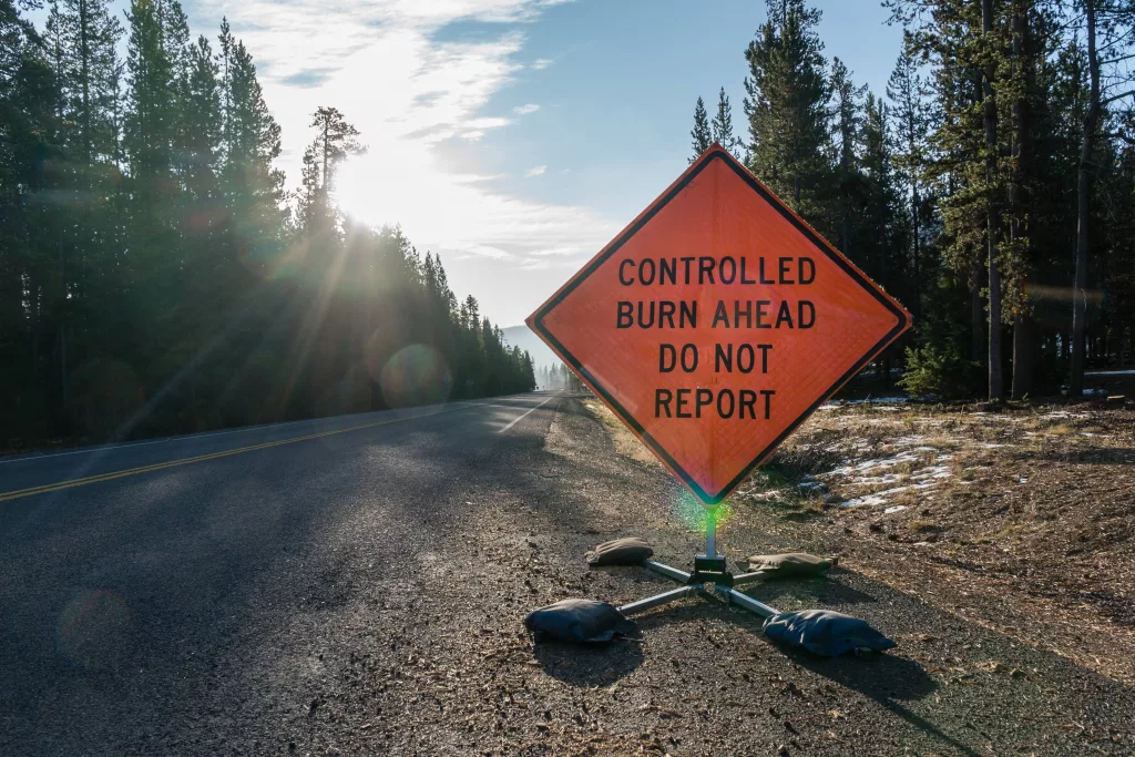
If conditions are favorable on Wednesday, May 21, the Deschutes National Forest plans to conduct prescribed burn operations on the Bend-Fort Rock, Crescent and Sisters Ranger Districts.
Bend-Fort Rock Ranger District firefighters plan to conduct up to 215 acres of prescribed burning on Wednesday approximately one mile southwest of Bend and south of the Cascade Lakes Highway. Ignitions are planned for 113 acres on Big Eddy Block 1 Prescribed Burn located near the intersection of Cascade Lakes Highway and Forest Service Road (FSR) 41 along the eastern side of FSR 41. If conditions allow, firefighters will also conduct 102 acres of prescribed burning on Tiddlywinks Block 2 Prescribed Burn on the west side of FSR 41 on Wednesday. If conditions remain favorable on Thursday, firefighters will ignite up to 267 acres on the Tiddlywinks 4 Prescribed Burn. Ignitions are planned for 10 a.m.
The following road and trail closures will be in place:
- Road access to Lava Island Day Use & Trailhead
- All trails north of Big Eddy Day Use
- Northern portion of Catch & Release Trail
- Storm King
Roads and trails will be closed during ignitions and until roadside and trailside hazards are mitigated. The Cascade Lakes Highway and Forest Service Road 41 will remain open. A pilot car will be implemented if smoke limits visibility. Smoke will be visible from Bend and the surrounding area. Residents in Bend and those south and east of the Deschutes River, including Sunriver, La Pine and Redmond are encouraged to keep doors and windows closed to minimize smoke impacts. Smoke impacts are most likely overnight and in the early morning hours.
Firefighters on the Crescent Ranger District plan to conduct up to 145 acres of ignitions on the 5-Mile Unit 12 Prescribed Burn located approximately seven miles southwest of Crescent and directly along the west side of Highway 97. Ignitions are planned for 9 a.m. A portion of Forest Service Road 9758 will be closed from the junction with Highway 97 west for three tenths of a mile to the intersection with the pipeline. Smoke will be visible from Highway 97 and 58, Crescent and the surrounding area. Residents in Crescent are encouraged to keep doors and windows closed to minimize smoke impacts. Smoke impacts are most likely overnight and in the early morning hours. Smoke impacts are also possible across Highway 97 during ignitions and overnight in the early morning hours. Flaggers will be present along Highway 97.
Wednesday, the Sisters Ranger District plans to conduct 54 acres of prescribed burning on SAFR 46 Prescribed Burn located three quarters of a mile south of Sisters at the intersection of FSR 16 (Three Creek Lake Road) and FSR 4606. Smoke will be visible from Sisters and the surrounding area. While no road or trail closures are anticipated, smoke may impact FSR 16, FSR 4606 and trails in the Peterson Ridge trails system. Flaggers will be available if smoke impacts roadways. Residents in Sisters and the surrounding area are encouraged to keep doors and windows closed to minimize smoke impacts. Smoke impacts are most likely overnight and in the early morning hours.
Firefighters implement understory prescribed burning to reduce wildfire risk to communities. Prescribed burning reintroduces and maintains fire within our fire-dependent ecosystem by removing concentrations of vegetation and restoring forest health while increasing public and firefighter safety.
Fire management officials work with Oregon Department of Forestry smoke specialists to plan prescribed burns. Prescribed burns are conducted when weather is most likely to move smoke up and away from our communities. While prescribed fire managers take significant preventive measures, it’s likely that communities may experience some smoke during or immediately after a prescribed burn.
What does this mean for you?
During prescribed burns, smoke may settle in low-lying areas overnight and in the early morning hours.
- All residents are encouraged to close doors and windows at night to avoid smoke impacts.
- If available, use a portable air cleaner. Air cleaners work best running with doors and windows closed. You can also create a DIY air cleaner.
- If you have a central air system, use it to filter air. Use high-efficiency filters if possible.
- When driving in smoky areas, drivers should slow down, turn on headlights and turn air to recirculating.
- If you have heart or lung disease, asthma, or other chronic conditions, pay attention to how you feel and if symptoms of heart or lung disease worsen, consider contacting your health care professional.
- Go to centraloregonfire.org to learn more about smoke safety and prescribed burning in Central Oregon and visit When Smoke is in the Air for more smoke preparedness resources.
For more information on prescribed burning in Central Oregon, visit centraloregonfire.org/ and for information specific to the Deschutes National Forest visit fs.usda.gov/r06/deschutes. Follow us on X/Twitter @CentralORFire. Text “COFIRE” to 888-777 to receive wildfire and prescribed fire text alerts.